یک مقاله عربی ادعا کرده است که پلینی خلیج عربی گفته است و نه خلیج فارس .
فقط گفتار زیر را بخوانید ببینید پلینی جه گفته است
متن عربی کاملا برعکس ترجمه شده است.
Gaius Caecilius Cilo (61 – ca. 112), better known as Pliny the Younger
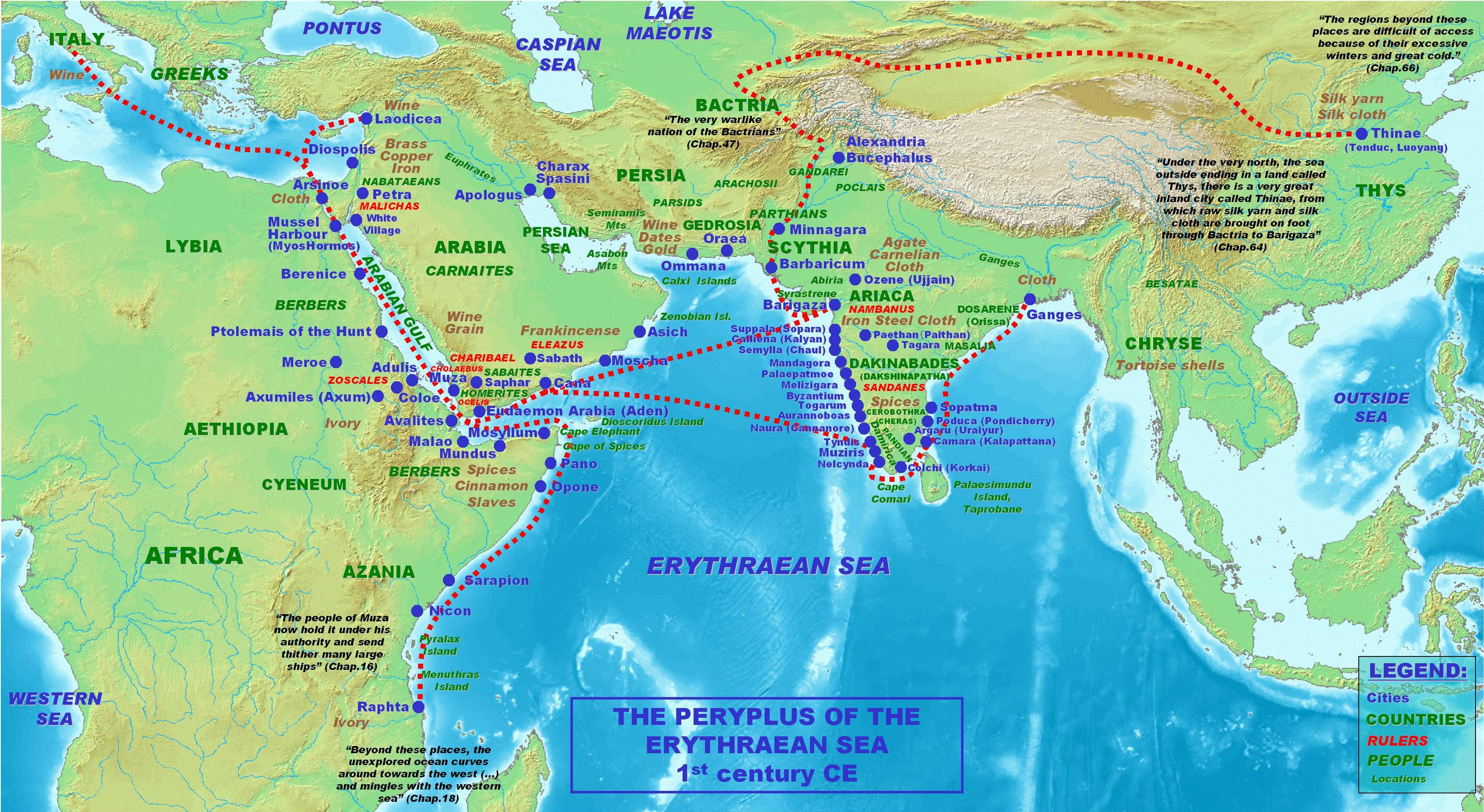
Pliny: Natural History 6.96-111. (On India)
XXVI [96] But before we go on to a detailed account of these countries, it is suitable to indicate the facts reported by Onesicritus after sailing with the fleet of Alexander round from India to the interior of Farsistan, and quite recently related in detail by Juba, and then to state the sea-route that has been ascertained in recent times and is followed at the present day.
The record of the voyage of Onesicritus and Nearchus does not include the names of the official stopping places nor the distances travelled; and to begin with, no sufficiently clear account is given of the position of the city of Timbertown, founded by Alexander, which was their starting point, nor is the river on which it stood indicated. Nevertheless they give the following places worth mentioning: [97] the town of Arbis, founded by Nearchus during his voyage, and the river Arbium, navigable by ships, and an island opposite to Arbis, 81 miles distant; Alexandria, founded in the territory of this race by Leonnatus at the order of Alexander; Argenus, with a serviceable harbour; the navigable river Tonberum, in the neighbourhood of which are the Parirae; then the Fish-eaters, covering so wide a space of coast that it took 30 days to sail past them; the island a called the Isle of the Sun and also the Couch of the Nymphs, the soil of which is red in colour, and on which all animals without exception die, from causes not ascertained; [98] the Ori tribe; the Carmanian river Hyctanis, affording harbourage and producing gold. The travellers noted that it was here that the Great and Little Bear first became visible, and that Arcturus is not visible at all on some nights and never all night long; that the rule of the Persian kings extended to this point; and that copper, iron, arsenic and red-lead are mined here. Next there is the Cape of Carmania, from which it is a passage of five miles to cross to the Arabian tribe of the Macae on the opposite coast; three islands, of which only Oracta, 25 miles from the mainland, has a supply of fresh water and is inhabited; [99] four islands quite in the gulf, off the coast of Farsistan — in the neighbourhood of these the fleet was terrified by sea-serpents 30 ft. long that swam alongside — ; the island of Aradus and that of Gauratae, both inhabited by the Gyani tribe; at the middle of the Persian Gulf the river Hyperis,
navigable for merchant vessels; the river Sitioganus, up which it is seven days’ voyage to Pasargadae; the navigable river Phrystimus; and an island that has no name. The river Granis, carrying vessels of moderate size, flows through Susiane, and on its right bank dwell the Deximontani, who manafacture asphalt; the river Zarotis, the mouth of which is difficult to navigate except for those familiar with it; and two small islands. Then comes a shallow stretch of water like a marsh which nevertheless is navigable by way of certain channels; the mouth of the Euphrates; a lake formed in the neighbourhood of Charax by the Eulaeus and the Tigris; then by the Tigris they reached Susa. [100] There after three months’ voyaging they found Alexander celebrating a festival; it was seven months since he had left them at Patala. Such was the route followed by the fleet of Alexander; but subsequently it was thought that the safest line is to start from Ras Fartak in Arabia with a west wind (the native name for which in those parts is Hippalus) and make for Patale, the distance being reckoned as 1332 miles. [101] The following period considered it a shorter and safer route to start from the same cape and steer for the Indian harbour of Sigerus, band for a long time this was the course followed, until a merchant discovered a shorter route, and the desire for gain brought India nearer; indeed, the voyage is made every year, with companies of archers on board, because these seas used to be very greatly infested by pirates.
XXVII [107] Nearchus writes that the length of the coast of Carmania is 1250 miles, anct the distance from its beginning to the river Sabis 100 miles; and that from that river to the river Ananis, a space of 25 miles, there’ are vineyards and arable land.’ The district is called Armysia; and towns of Carmania are Zetis and Alexandria.
XXVIII. Moreover in this region the sea then makes a double inroad, into the land; the name given to it by our countrymen is the Red Sea, while the Greeks call it Erythrum, from King Erythras, or, according to others, in the belief that the water is given a red colour by the reflexion of the sun, while others say that the name comes from the sand and the soil, and others that it is due to the actual water being naturally of such a character. [108] However, this sea is divided into two bays. The one to the east is called the Persian Gulf, and according to the report of Eratosthenes measures 2500 miles round. Opposite is Arabia, with a coastline 1500 miles in length, and on its other side Arabia is encompassed by the second bay, named the Arabian Gulf; the ocean flowing into this is called the Azanian Sea. The width of the Persian Gulf at its entrance some make five and others four miles ; the distance in a straight line from the entrance to the innermost part of the Gulf has been ascertained to be nearly 1125 miles, and its outline has been found to be in the likeness of a human head. [109] Onesicritus and Nearchus write that from the river Indus to the Persian Gulf and from there to Babylon by the marshes’of the Euphrates is a voyage of 1700 miles.
In an angle of Carmania are the Turtle-eaters, who roof their houses with the shells and live on the flesh of turtles. These people inhabit the promontory, that is reached next after leaving the river Arabis. They are covered all over, except their heads, with shaggy, hair, and they wear clothes made of the skins of fishes. [110] After the district belonging to these people, in the direction of India there is said to be an uninhabited island, Cascandrus, 50 miles out at sea, and next to it, with a strait flowing between, Stoidis, with a valuable pearl-fishery. After the promontory the Carmanians are adjoined by the Harmozaei, though some authorities place the Arbii between them, stretching all along the coast for 421 miles. Here are the Port of the Macedonians and the Altars of Alexander situated on a promontory; the rivers are Siccanas and then the Dratinus and the Salsum. [111] After the Salsum is Cape Themisteas, and the inhabited island of Aphrodisias. Here is the beginning of Farsistan, at the river Tab, which separates Farsistan from Elymais. Off the coast of Farsistan lie the islands of Psilos, Cassandra and Aracha, the last with an extremely lofty mountain, and consecrated to Neptune. Farsistan itself occupies 550 miles of coast, facing west. It is wealthy even to the point of luxury. It has long ago changed its name to Parthia.
This text is part of the .
Source:
=== the Persian Seaa nd the Persian Gulf in
The Periplus of the Erythraean Sea:
Travel and Trade in the Indian Ocean by a Merchant of the First Century
34. Sailing along the coast, which trends northward toward the entrance of the Persian Sea, there are many islands known as the Calxi, after about two thousand stadia, extending along the shore. The inhabitants are a treacherous lot, very little civilized.
35. At the upper end of these Calaei islands is a range of mountains called Calon, and there follows not far beyond,
the mouth of the Persian Gulf, where there is much diving for the pearl-mussel. To the left of the straits are great mountains called Asabon, and to the right there rises in full view another round and high mountain called Semiramis; between them the passage across the strait is about six hundred stadia; beyond which that very great and broad sea, the Persian Gulf, reaches far into the interior. At the upper end of this Gulf there is a market-town designated by law called Apologus, situated near Charax Spasini and the River Euphrates.
36. Sailing through the mouth of the Gulf, after a six-days’ course there is another market-town of Persia called Ommana. To both of these market-towns large vessels are regularly sent from Barygaza, loaded with copper and sandalwood and timbers of teakwood and logs of blackwood and ebony. To Ommana frankincense is also brought from Cana, and from Ommana to Arabia boats sewed together after the fashion of the place; these are known as madarata. From each of these market-towns, there are exported to Barygaza and also to Arabia, many pearls, but inferior to those of lndia; purple, clothing after the fashion of the place, wine, a great quantity of dates, gold and slaves.
آخرین دیدگاهها